
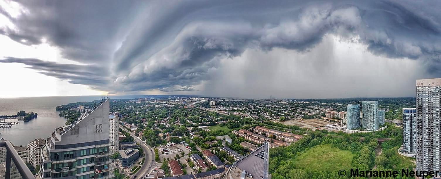
Kiters’ Digest – Cherry Beach Special Edition
In light of the recent, weather-related accident that happened to our friend Jason, I felt compelled to write this article as a meaningful step to prevent such a tragedy from ever happening again.
With the weather growing more extreme in many parts of the world, it’s becoming more and more obvious that kitesurfing totally lacks an educational structure explaining weather phenomena that we should all understand in order to maintain our personal safety while enjoying this beautiful sport. How much did you learn about dangerous weather elements from your kiting instructors?
I have written a “Kitesurfing Meteorology Crash Course”, which I believe is relevant not only for the Toronto area, but also for many other locations around the world. You will find it in Appendix A of this article and I hope you will eventually find some time to read it. The more weather-knowledgeable kitesurfers we have around us, the less “extreme” our sport will be.
More importantly, as a long time kitesurfer in the GTA and an experienced weather observer, I would like to draw your attention to 2 important points directly related to Cherry Beach. First, I want to discuss two very similar weather scenarios that we experience here in the GTA, one of which can have extreme consequences. I want to make sure that everybody understands and recognizes The Southerly Threat of Cherry Beach. Second, I want to put forward some ideas and thoughts about a “kitesurfing weather warning system” which we can have in place almost instantly!
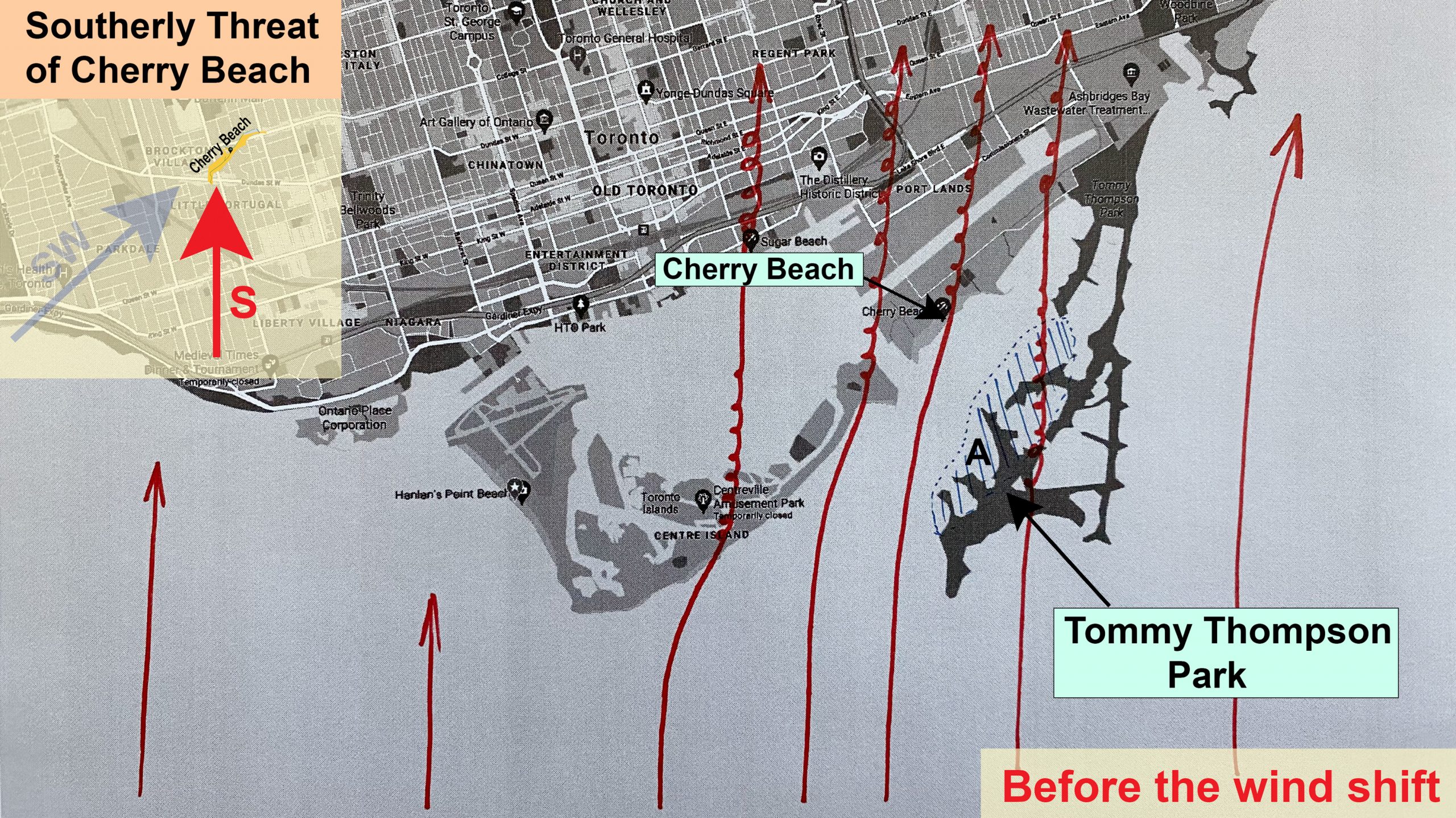
A Typical Day at Cherry Beach
Let’s start with a typical day at Cherry that will be very familiar to us all. There is a beautiful SW wind forecast for most of the day, with a typical westerly wind shift expected sometime in mid or late afternoon. The wind shift usually occurs either because of a cold front passing through or isolated thunderstorms developing in the GTA.
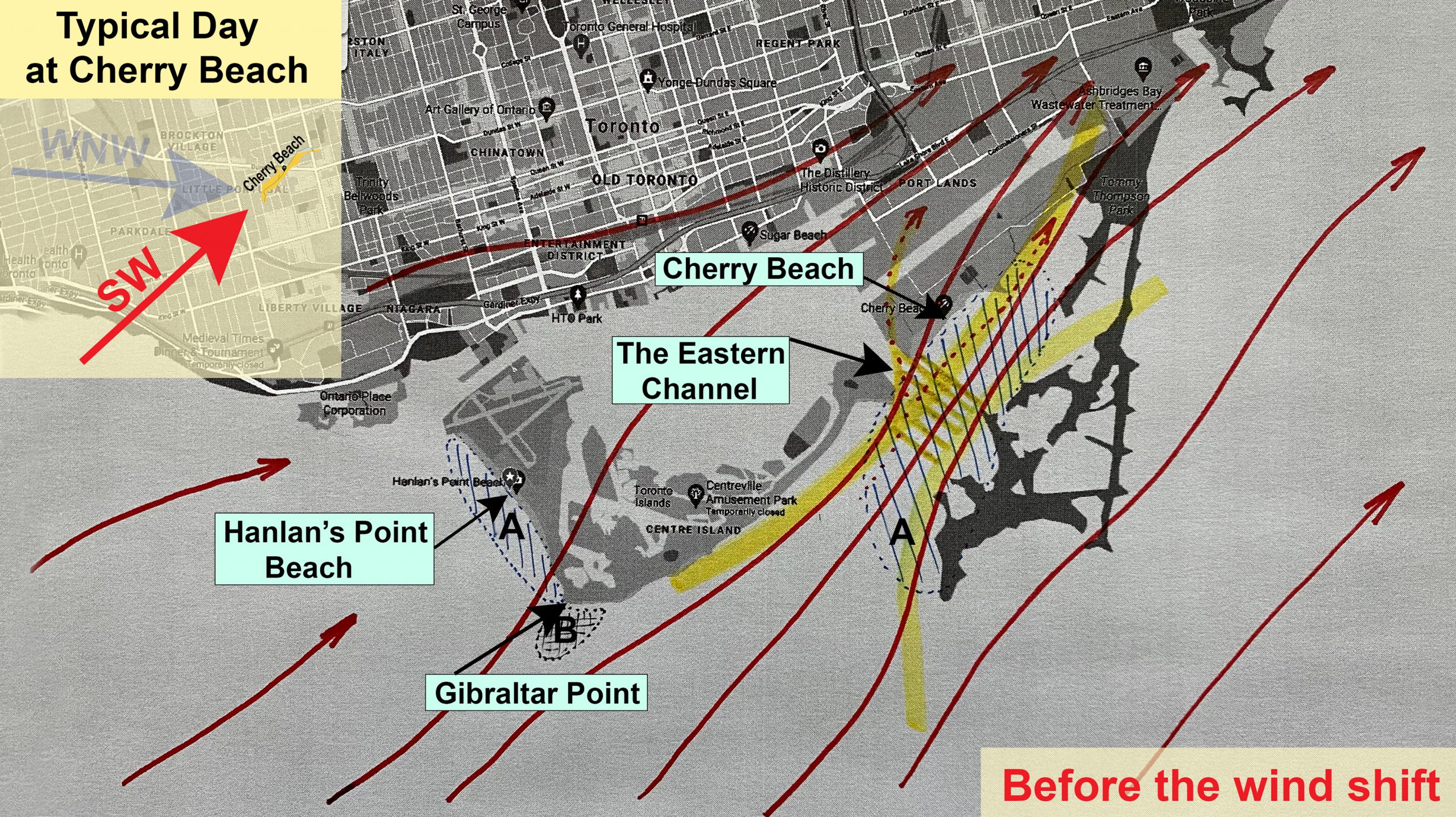
A few points to note:
- SW-SSW wind is the most ideal for this location.
- The Cherry Beach bay features the Venturi effect, due to the topography of the surrounding area. Even during light wind sessions, a true wind connoisseur will often find a few extra knots at the mouth of the Eastern Channel. The channel is the easiest “escape route” for the wind energy that enters the dead-end bay. Additionally, the narrowest section of the whole bay is just in the vicinity of the Eastern Channel, so that’s where the resulting effect is most pronounced.
- The highlighted areas marked “A” are known for their great doming effect when the conditions are right. Why? During cool spring nights, when the water temperatures are still very low, a thin layer of cold air develops immediately above the water’s surface. During the day, when the SW breeze starts to come in, this heavier and “lazier” layer of air gets “stuck” in the dead-end bay and functions like an invisible pillow, over which slightly warmer air starts to slide. While doming occurs at other locations around the city, when the conditions are right, Cherry provides one of the best jumping locations in the whole GTA. With this doming benefit also comes one disadvantage, though; It usually takes much longer for kitable wind to “penetrate” deep into the bay.
- The highlighted area marked “B” is the “Gibraltar Point Wind Hole”. As I often kite the waters between Humber Bay and the Cherry Beach light house, I can confirm this strange phenomenon. If you stay very close to the shore when you round Gibraltar Point, you may experience a fairly significant wind drop. It is safer to stay slightly further (100-200m) away from shore.
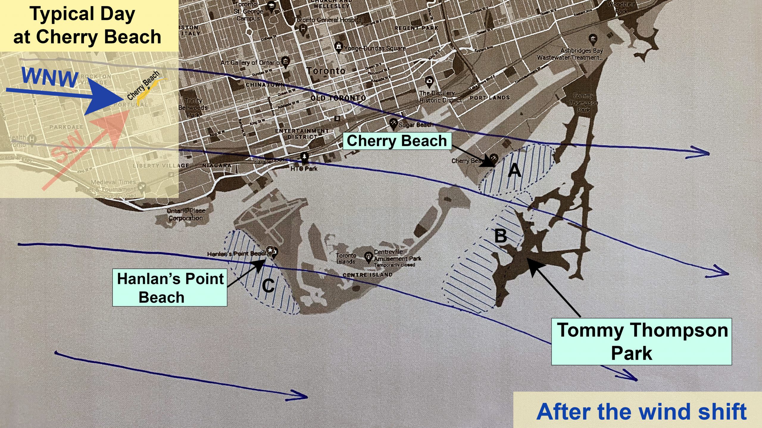
When the wind switches to W-NW, Cherry Beach becomes an un-kitable location. Area “A” becomes very gusty, the winds are offshore, and the possibility of getting lofted during kite launches and landings is high. If the wind shift happens gradually (and that WILL NOT happen when a cold front is passing through), it is still possible to kite safely in area “B”. This practice requires experience and skill, though, as getting back to Cherry Beach is tricky. Hanlan’s Point Beach on Toronto Island (depicted area “C”) is the only safely-kitable location for W-WNW winds in the GTA.
Before I contrast the next weather scenario, which I call “The Southerly Threat of Cherry Beach”, I need to make the following important points about the typical passage of a cold front:
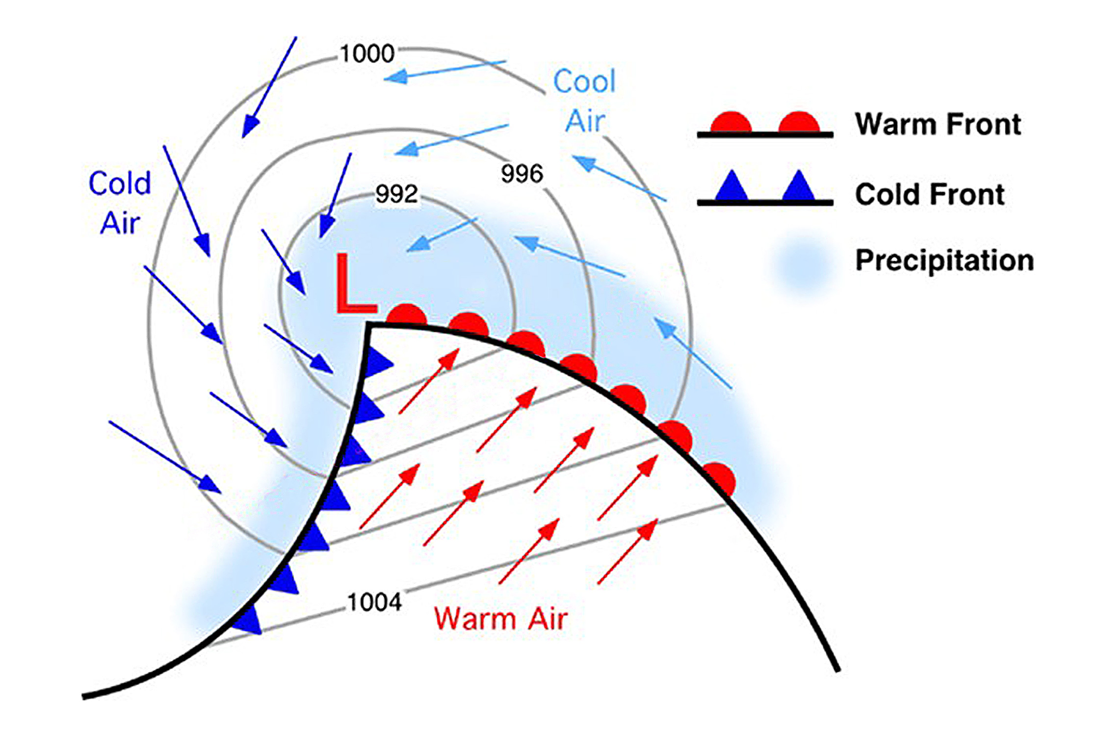
- As you can read in Appendix A, cold fronts generally move from northwest to southeast. Winds ahead of a front are typically out of the south-southwest, but once the front passes through, the wind quickly shifts to the west-northwest.
- When a violent gust front barrels towards the GTA ahead of a squall line, it is significantly slowed down by friction over the expansive urban area, and literally torn apart by Toronto’s downtown skyscrapers. While the overall gustiness and mechanical turbulence increases during the front’s passage over the GTA, its gust peaks are greatly reduced.
- When the gust front approaches Cherry Beach, it faces a barrage of trees at the dog park. This tree line further dampens the wind force experienced on the beach and also in the depicted area “A” in the picture above.
- Kiters who are caught on the water when the gusty winds arrive experience greatly reduced wind violence compared to its original or forecast peaks. Kiters caught on the beach with their kites up won’t get lofted into the trees at the dog park, and still have a fighting chance to land in the less obstructed area, in case they do get lofted.
- No weather arrives unannounced! Kiters who are experienced with the weather conditions at their home kiting locations, and who are attuned to the weather while riding, usually feel “the last call” before the wind dies or before the shift happens. It is that “pop” you feel in your kite caused by sudden wind fluctuations announcing that the wind change is imminent. This trigger, however, can’t be trusted when a severe cold front is expected to roll through. It comes too late.
- In many ways, Toronto downtown, Toronto Island, and the topography around Cherry Beach shelter kiters from the most violent wind-related weather elements associated with cold fronts and thunderstorms.
All of the circumstances above, coupled with the lack of weather education among kiters in general, and combined with the usual kitesurfers’ risk/adventure-taking mindset, may very well contribute to their under-estimating severe weather that can occur in Toronto.
The Southerly Threat of Cherry Beach
It is not unusual to have a beautiful south wind in Toronto. In fact, south wind means a great day for kiters along the whole northern shore of Lake Ontario, a stretch of about 300 kilometers. South winds are typically lighter than southwesterlies and thunderstorm activity is very rare. Toronto is generally “protected” by Lake Ontario and by the proximity of Lake Erie. Isolated thunderstorms hardly ever form over the water because the conditions are not favorable for convective activity. Many times, it is clearly visible that inclement weather cloud systems weaken and start to dissipate when they are affected by the Great Lakes in our area.
As noted in Appendix A, cold fronts generally move from northwest to southeast in the northern hemisphere. Winds ahead of a cold front blow from the SW and switch to W-NW when the front passes through. However, when a cold front approaches from the southwest, the winds will blow from the south ahead of the front and switch to W-SW when it passes by. Technically speaking, it is the same scenario, but rotated anticlockwise by 50 degrees or so. See the picture below.
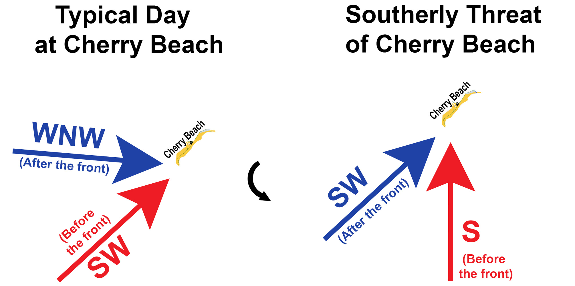
When a well-developed cold front with severe thunderstorms at its leading edge comes from the southwest, its self-feeding nature allows it to “jump over” Lake Ontario without even “feeling” it. The front moves over the lake so quickly that the dissipating process is negligible or may not even start. When this happens, kiters everywhere along the northern shore of Lake Ontario need to pay extra attention! The significant difference between these two weather scenarios may not be readily obvious, and so I thoroughly examine the situation in the next few paragraphs.
There is not much to say about the picture above. It’s a good kiting day. I show area “A” as a slightly turbulent zone where the wind is not so great due to mechanical turbulence caused by friction over the trees at Tommy Thompson Park.
Let’s have a look at the situation when a severe cold front coming from the SW is about to pass through. For many reasons, this is one of the most dangerous weather scenarios for Cherry Beach!
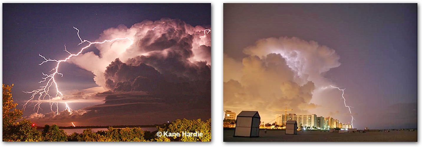
A violent gust front preceding an ominous line of severe thunderstorms forming the leading edge of a cold front barrels towards Cherry Beach unimpeded and at full force! There is very little surface friction over the lake and no obstacles to slow it down. A gust front can be so powerful that it can capsize a sailboat or a small vessel. Additionally, the very humid air above the lake, hand in hand with the overall instability of the pre-frontal airmass, may produce a low-level scud cloud with occasional drizzle or light rain. This pre-frontal cloud cover can partially obscure significant weather rapidly approaching at some areas. While there may be an ominous squall line visible on the horizon for some kiters, this visual clue may be partially obstructed for others. As you can read in my “weather crash course” in Appendix A, strong gust fronts can precede the cold front precipitation region by tens of kilometers, and the wind peaks can register well over 70kts.
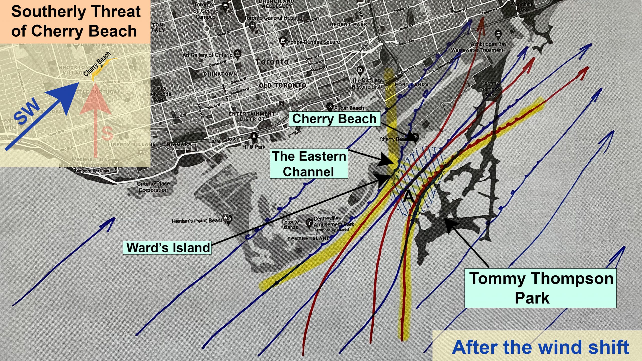
From this picture, it is very apparent that the Venturi effect can be magnified by the southern pre-frontal wind being “bent” into the bay by abrupt southwesterly gusts. All of a sudden, a turbulent mixture of both air masses wants to rush through the dead-end Cherry bay. The Eastern Channel becomes the “easiest exit” in this southerly scenario, and it allows the air to accelerate more easily through its narrowest part. With wind speeds gusting well over 40kts, the mechanical turbulence in the whole area becomes severe on its own. Area “A” takes the full brunt of all of the elements combined: Turbulence generated by Tommy Thompson Park from the south, turbulence generated by the Ward’s Island breakwall at the end of its beach, the “reverberating” turbulence caused by the tree line at the dog park – all mixed together with the gust front energy accelerated by the Venturi effect! I hope this sounds scary enough for everyone to pay extra attention to The Southerly Threat of Cherry Beach from now on!
Very important points to note:
- An unimpeded severe gust front can move along the water surface at nearly 2km per minute! It is too late if you wait for the weather to come close, and it is too late if you wait for any “trigger” to announce the weather change.
- With the wind direction mixture (unpredictable turbulence) anywhere between S-SW-W during the initial minutes of the gust front, it is entirely possible to be lofted into the tree line at the dog park, onto the parking lot, or in the shallow area in the water. It is crucially important to be out of the water well ahead of this type of inclement weather! If you feel you are too late, don’t even try to come onto the shore! Land your kite in the water, pull your release, wrap the kite, and swim back to shore. Don’t take any chances.
- As opposed to a typical cold front where the winds become unrideable after the switch, the wind direction after the Southerly Threat of Cherry Beach passes through may be still favorable to resume kiting. However, be very vigilant of a “pseudo-cold front” which may arrive unannounced among the mix of cloud and strong winds already in the area. This “secondary gust front” originates in the rear-flank downdraft of the thunderstorm and can bring gust peaks as high or even higher than the initial gust front.
- Remember, the Southerly Threat of Cherry Beach may not be fully obvious and scary-looking upon its arrival due to the low-level scud cloud forming over the lake. Every time there is a beautiful south wind forecast ahead of ANY cold front in the GTA, extra vigilance is needed!
I have been interested in meteorology all my life. I took a few courses in my teenage years, I have read a lot of books, and I have always enjoyed observing severe weather. In addition to my experience as a glider pilot, weather observation has been a part of my job description for the last 25 years, working as an air traffic controller. On the Cherry Beach topic, many years ago while I was kitesurfing on an 8m kite, I got lofted right in the middle of the Cherry Beach bay close to the Eastern Channel. When I hit the water, the impact knocked the air out of me. Luckily, my foil kite never relaunched on its own, and I had time to regain calm and slowly recover my breathing. The same gust totally ripped Jason’s experimental 9m kite off of all 4 of its flying lines. He returned to Cherry Beach on foot and the kite fabric was recovered by other kiters. With all this experience in place, I am kicking myself now that I was unable to put two and two together, summarize my thoughts, and spell out the info in this article before Jason’s tragic accident. Things could have turned out differently. However, I do have hope that nobody will be caught by adverse weather again at Cherry Beach after reading this piece. Please don’t skip Appendix C, where I have summarized a few useful tips.
Kitesurfing Weather Warning System
After Jason’s accident, local kiters erupted on social media with many good ideas about what we could do as a community to prevent such a tragedy from happening again. One brief topic that caught my attention was a kitesurfing weather warning system. While I thought that most of the ideas presented were naïve and unrealistic, I realized that, in fact, we could have such a magical system in place tomorrow!
There is a very large kitesurfing community around the GTA, but of course not everybody can kite every time there is wind. People go to work, they have family responsibilities and other projects or chores to do, and so on. Instead of feeling frustrated that you can’t go kiting on a certain day, maintain a healthy and positive state of mind by staying involved, and become a safety pillar for your fellow kiters. “If you see something, say something!” If you see heavy rain and squalls coming through Mississauga, for instance, send that text message out! When kiters at Kipling experience an abrupt wind shift, send that message out! When Cherry is shut down by weather, someone has to send that message out! FMB kiters may still be out riding, and may find this weather chasing trail very useful! If I happen to be sitting at work at YYZ and a squall rolls though, I promise I will send that message out! We can be the most accurate and descriptive “sensors” of our own warning system! As I mentioned above, no weather arrives unannounced. Collectively, we can make sure that no kiter has to be surprised. As an example, a kiter at Cherry Beach could make a better decision about whether or not to launch a kite and go riding if he/she knows that the wind at Kipling has just shifted to W-NW! I have seen a few people doing this already, so let’s make it an organized and reliable effort! There is one more important ingredient needed for this plan to work, though. Many of us don’t like to kite with a cellphone. You may ask: “How will I get the information while I am out riding?”
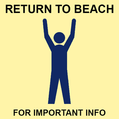
Visual signals matter! When we need help to land our kite, we tap our hand on top of our head/helmet, using an internationally recognized kitesurfing sign. But how do we call a kiter back to the beach? There must also be a well-recognized visual signal, right? Surely, there are many important reasons to call people out of the water, such as sharks spotted in the area, dangerous weather, family emergency, dangerous currents, beach bar finally open, and so on. Believe it or not, apart from the whistle that a lifeguard would use (useless to a kiter), I found NOTHING! I searched the web – but to no avail. I am shocked! Admittedly, being a lone kiter, I don’t really know much about the common etiquette of popular kiting locations. You have to help me out here, but if this is true, maybe it’s time for us to change the situation. Maybe it’s calling for our Toronto kitesurfing community to come up with a signal/sign and make it internationally recognized in Jason’s honor.
Here is my idea. There are not many things that kitesurfers really care about while riding, except one thing: “Who is watching my antics from the beach?” In other words, it should be very easy to grab a kitesurfer’s attention if somebody stood on the beach with both of their arms up, for instance. If I know that this particular gesture means that there is some urgent information that I need to know, I will come to shore to hear it. Wouldn’t you?
Well, thank you for reading my words. I hope somebody will take it from here, build on these thoughts, and perhaps, help to bring some of my ideas to fruition. I would love to see our local “kitesurfing weather warning system” fully operational, and mainly, I’d like to see nobody on the water when severe weather threatens.
Appendix A – Kitesurfing Meteorology Crash Course
In this appendix, I will focus on cold fronts and associated weather phenomena that can pose great danger to kitesurfers. In order to avoid very risky situations, every kiter needs to be familiar with the basic processes and forces behind these weather elements.
Cold Front
A cold front is the transition zone where a cold air mass replaces a warmer air mass. On the northern hemisphere, cold fronts generally move from northwest to southeast. Winds ahead of the front are typically out of the south-southwest, but once the front passes through, the wind quickly shifts to the west-northwest. Indeed, this is a very common scenario for the Toronto area.
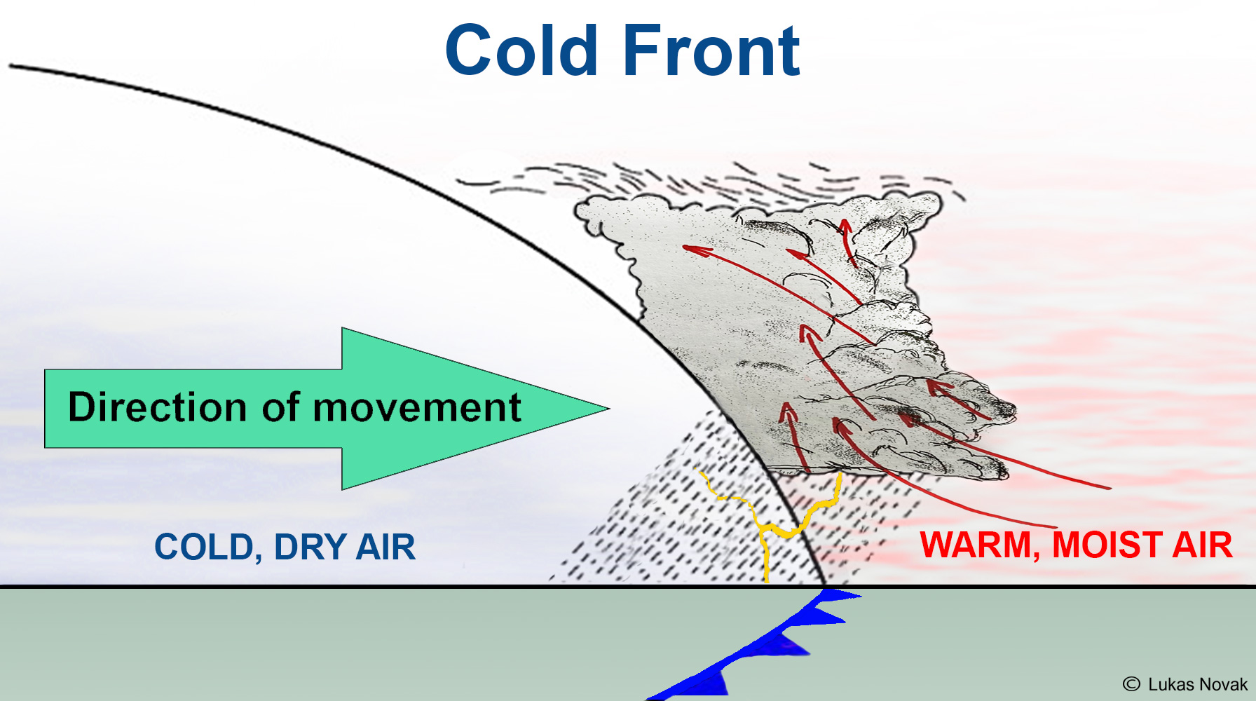
From the kitesurfing point of view, it is important to know that an approaching cold front manifests itself as a line of potentially severe thunderstorms accompanied by meteorological phenomena including gust fronts, microbursts, low-level jets, straight-line winds, mechanical turbulence, and more – all of which need to be avoided. Nobody should be attached to a kite when such weather hits, because it can be extremely dangerous!
Thunderstorm Lifecycle
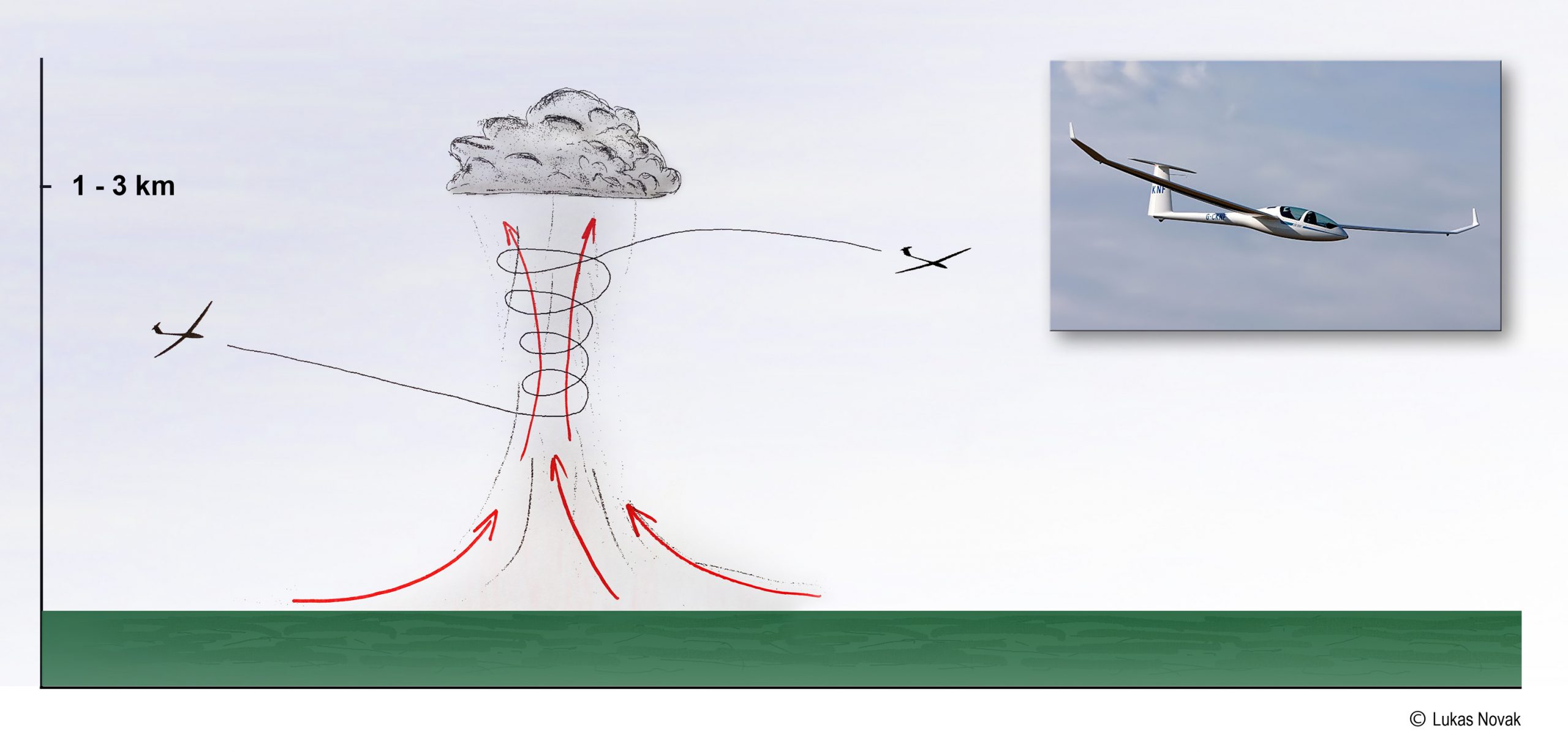
The three main ingredients that are needed for a thunderstorm to occur are high humidity, air instability, and a trigger that initiates warm air to rise. A trigger can be caused by frontal lifting, orographic effects, or surface heating. As an example of a surface heating trigger, think of a moving car on a less-traveled country road. As the dark asphalt of the road heats up, the air above the road becomes warmer than the air sitting above the surrounding farm fields. As the car goes by, it stirs the air above the road, and that is the trigger – the initial motion/energy – for the warm air to start rising. And that’s it. If the conditions are right, the process of forming a potentially devastating thunderstorm has been initiated.
As the warm air rises, it forms an updraft. These updrafts are only tens to a few hundred meters wide and are invisible unless you can see some dust or hay, for instance, being swooped from the ground. Many birds and glider pilots seek updrafts as they provide “free” altitude gain. Kitesurfers can care less, however, as these updrafts don’t pose any danger and they don’t normally form above the water.
Air instability is necessary for the updraft to maintain its “buoyant energy”. As a column of rising warm air exchanges heat with surrounding colder air, it slowly cools down. This process is called convection. With the right conditions, the rising air will eventually reach an altitude at which the water vapor condenses into liquid and thus creates a cloud base. During this condensation process, latent heat is released, and this heat becomes the primary energy source for further development of a thunderstorm. The higher the humidity, the more latent heat is released, and the stronger the thunderstorm becomes.
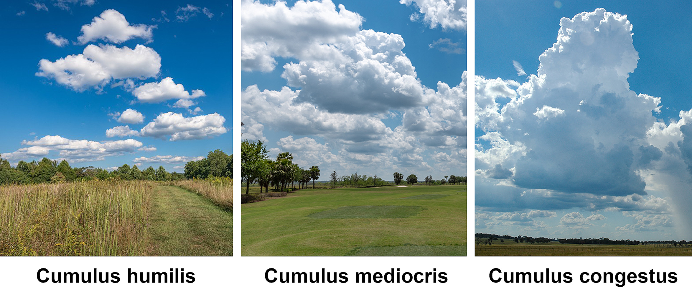
If there is no stabilizing layer in the higher atmosphere that can stifle the vertical development of the cloud, the puffy Cumulus clouds (Cumulus Humilis -> Cumulus Mediocris -> Cumulus Congestus – which are no threat to kitesurfing) grow further into a deep convective Cumulonimbus cloud that has a large vertical extent. If a Cumulonimbus cloud has thunder and lightning, it is called a thunderstorm.
The picture above shows a diagram of the most benign type of thunderstorm – Airmass (Isolated) Thunderstorm. Airmass thunderstorms typically occur in environments with similar properties and little wind shear. They are short-lived because the storm shuts off its ability to sustain itself. There are two main reasons this happens; (1) within the cloud, rain falls through the updraft region and reduces its strength (2) below the cloud base, the falling rain evaporates and cools the rising air. Without the warm buoyant air to drive further convection, the storm loses its strength and dissipates.
From the kitesurfing point of view, all dangerous elements such as gusty conditions, heavy rain, lightning, and reduced visibility remain within a relatively close range of the isolated thunderstorm cloud itself. As the storm approaches, there might be a change in wind speed and/or direction due to the storm “sucking” air towards the cloud. In general, though, there should be plenty of unmistakable natural warning signs of the approaching danger and time to exit the water well before the storm arrives. However, this may not be the case with quickly approaching severe squall lines.
Severe Thunderstorms
In order for a thunderstorm to become severe, one additional ingredient needs to be present, and that is wind shear. Wind shear is defined as a change of wind velocity and/or direction over a short distance. Vertical wind shear helps to tilt a storm so that the updraft and downdraft are displaced from one another. Without the competition between upward moving air and downward moving air, severe thunderstorms can strengthen and last much longer. Strong wind shear also pushes thunderstorms into areas with warm and humid air, which are a much needed “fuel” for convection. In favorable conditions, well developed thunderstorms literally become self-feeding monsters, causing destruction and havoc over extensive areas thanks to associated elements including hail, lightning, hurricane strength wind gusts, and tornados.
Cold-front-associated thunderstorms often contain multiple cells that are on different life cycles and can feed off of each other. They move as a linear propagating severe thunderstorm called a squall line. Squall lines can be many hundreds of kilometers long, but their width is usually much less, between 15 and 100 km. They can sustain themselves for several days.
The remaining two main types of severe thunderstorms are mesoscale convective complexes (MCCs), and supercells.
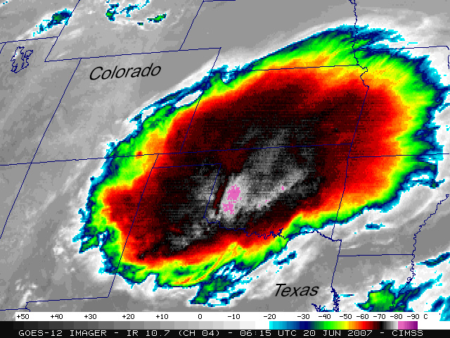
MCCs are truly impressive masses of convection but they are very rare in Toronto area. The Great Lakes literally protect the GTA from massive and sustained vertical development. The anvil of a mesoscale convective complex can expand to over 350 km in diameter.
Supercells are a special type of severe storms that have rotation. They form when the environment has directional wind shear that causes updrafts to not only separate clearly from downdrafts, but also to spiral upwards within the Cumulonimbus cloud. Such updrafts and downdrafts can attain speeds of over 160 km/h and are able to produce giant hail and damaging downbursts. Tornados can sometimes form in the rain-free zone of a supercell.
From the kitesurfing point of view, it is important to note that even though we don’t normally see tornados in the GTA, the supercell thunderstorms with destructive wind forces and precipitation do occur in our area during the summer season. According to Toronto’s Future Weather and Climate Study, observational evidence indicates that the storm tracks have been shifting poleward on our hemisphere over the last 50 years. As a result, mid-latitude locations, such as Toronto, are expected to experience fewer storms, but those that do impact the city in the future are likely to be more extreme. Additionally, out of 85 major cities around the world, Toronto is projected to experience the fourth largest climate shift by 2050 if nothing is done to curb global carbon emissions. This is yet another reason why the GTA may experience more severe weather in the future.
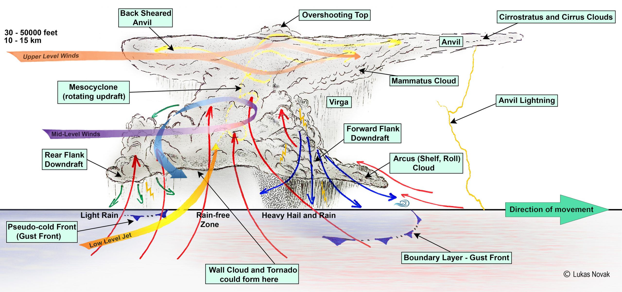
My passion for meteorology urges me to explain everything that I drew in the picture above, but because I want to stay focused on kitesurfing safety, I will discuss only the related phenomena including gust fronts, microbursts, straight line winds, anvil lightning and a few others that matter to kiters.
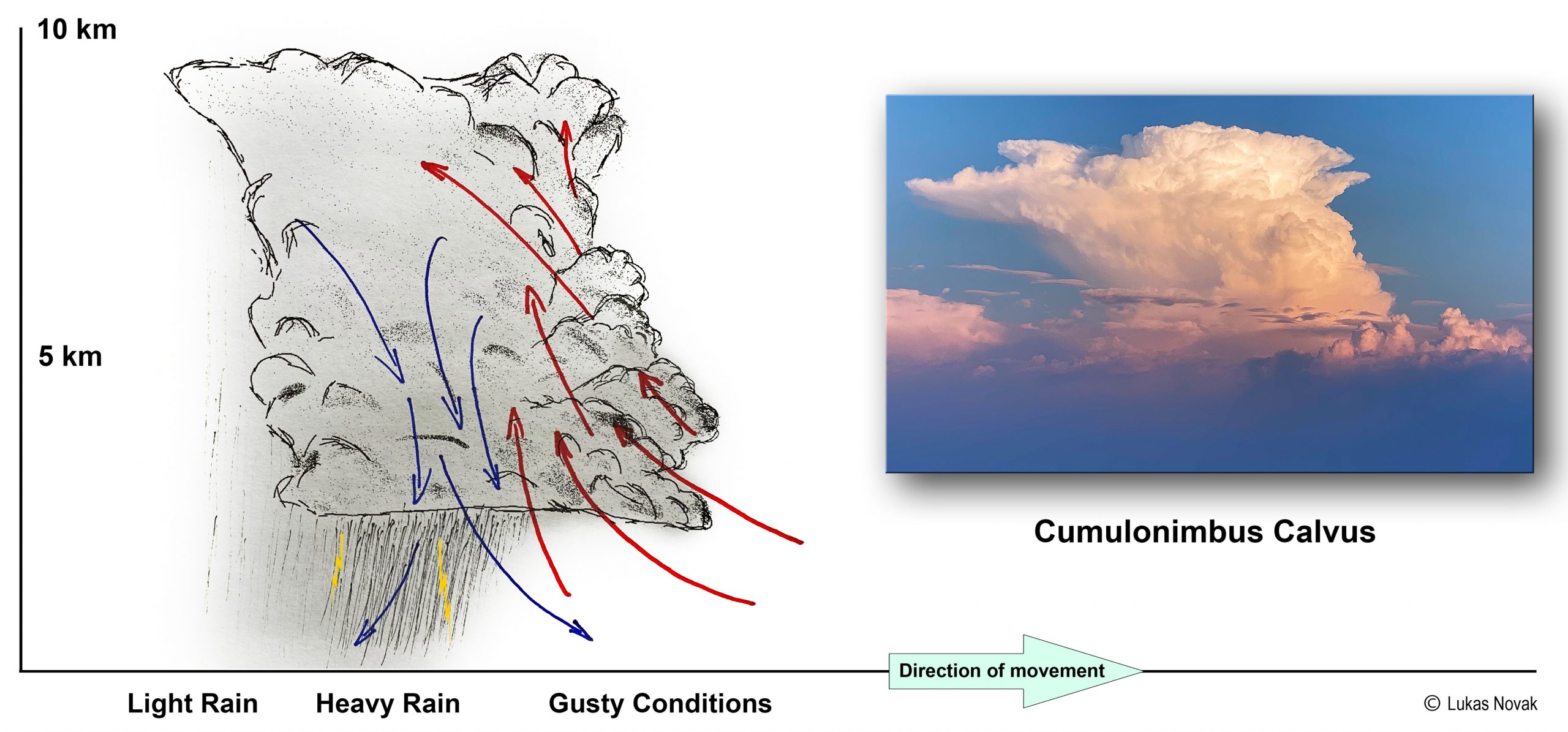
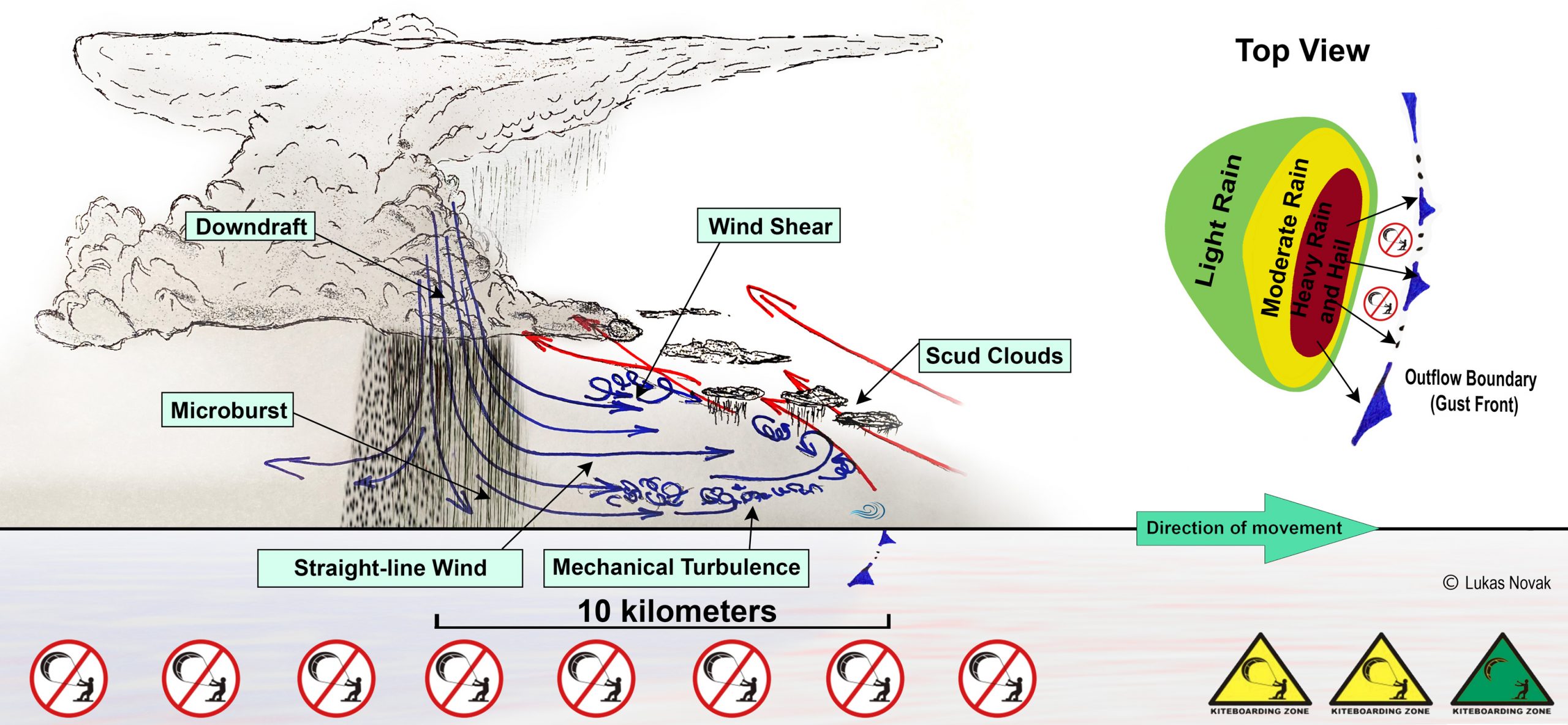
As explained above, in every mature thunderstorm, strong updrafts and downdrafts develop. The stronger the updrafts, the heavier the eventual precipitation will be. When the weight of water droplets, ice, or hail finally overcomes the lifting power of the rising air, the precipitation starts to fall towards the Earth through the massive Cumulonimbus cloud. When this happens, an interesting chain of events occurs; some of the precipitation evaporates, which causes the surrounding air to cool. As the updraft cools down, it loses its lifting power and, as a result, more precipitation starts to fall. Inevitably, this chokes the updraft even more. This “avalanche effect” is also strengthened by drag created between the falling precipitation and the surrounding air, which further widens the column of sinking air. Within a short time, tons of precipitation, literally, is hurtling down and gaining speed. The resulting downdraft can be visualized like a firehose pointed directly towards the Earth. When the winds hit the ground, they spread out horizontally in all directions with potentially devastating force equivalent to a tornado. In fact, the effects of a downburst are similar but completely opposite to those of a tornado. Tornados suck the air into the cloud and upwards, whereas downbursts spit the air downwards and away from the cloud. Depending on other factors, the meteorological terminology for these downbursts is either microbursts or macrobursts. The horizontal winds associated with them are termed straight-line winds.
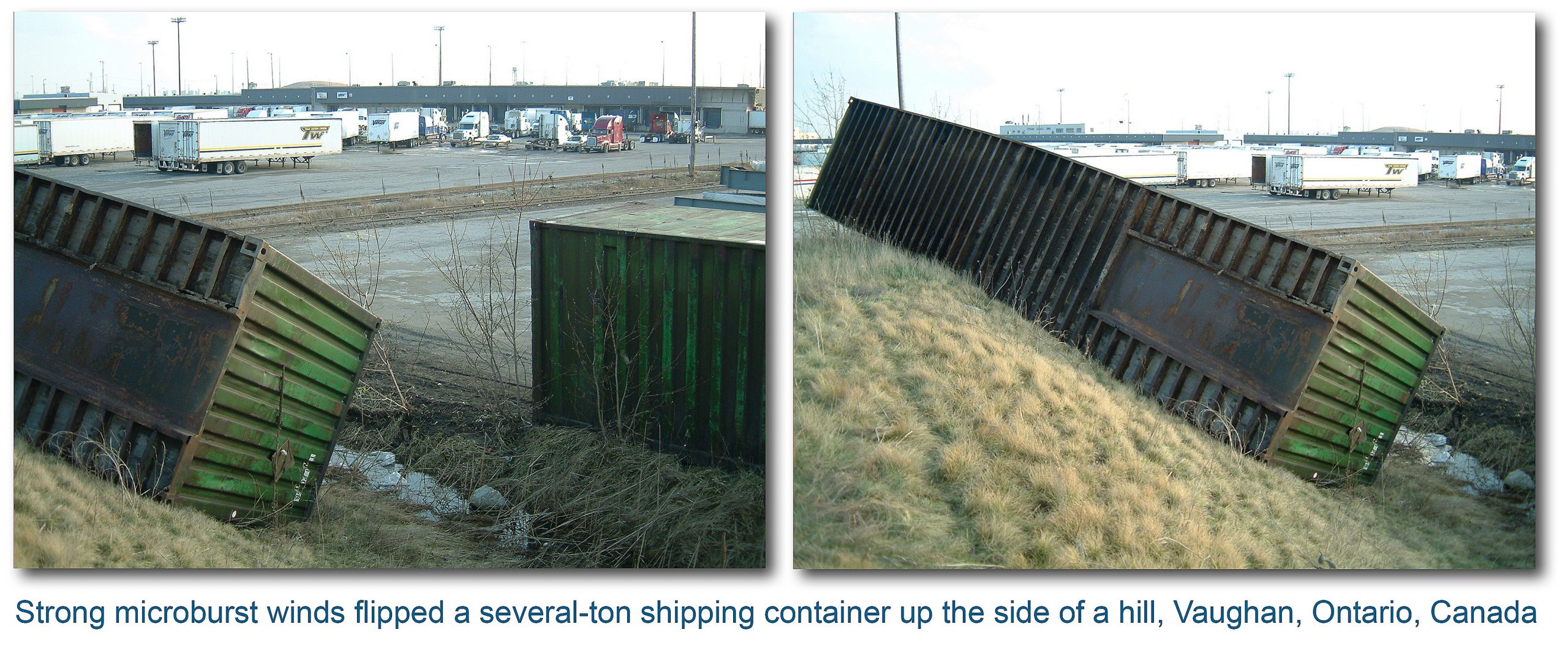
Microbursts are violent, short-lived, and very localized downdrafts with a diameter of influence of less than 4 km, lasting from a few seconds to several minutes. The wind speeds can reach well over 150 km/h, the equivalent of an EF-1 tornado. According to Guinness Book of World Records 2014, the strongest microburst was recorded at Andrews Field, Maryland on August 1, 1983, with wind speeds reaching 240 km/h (149 mph)
Macrobursts are larger than 4km in extent, last longer, and are typically less violent than microbursts.
Straight-line winds originate with a downburst and spread horizontally outwards, away from the thunderstorm. The gust peaks can reach 110kts and gusty winds of 50kts can last for more than twenty minutes. When these straight-line winds spread far enough in the same direction as the frontal squall line they originated from, they can reach the warm, moist pre-frontal airmass and spur the initiation of new thunderstorms. You can visualize this lifting process as a snowplow pushing fresh snow ahead and over its blade. The boundary of this turbulent outflow is called a gust front.
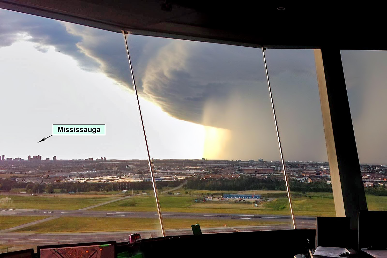
Gust fronts are lines of gusty wind moving out from a squall line or an area of severe thunderstorms. A gust front can extend 10s of kilometers parallel to the line of thunderstorms and it can be co-located with the appearance of roll clouds and shelf clouds.
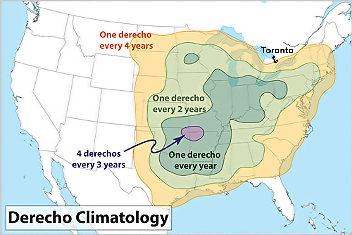
A fast-moving line of severe thunderstorms can be associated with straight-line winds called Derecho. While a precise definition is being debated, it will suffice to say that Derecho is made up of families of downburst clusters that extend continuously or nearly continuously for at least 250 miles (about 400km). Severe wind gusts greater than 57 mph occur at most points along the storm path. According to Wikipedia, Derechos in North America form predominantly from April to August, but during mid-summer, they will often develop farther north into Manitoba or Ontario, well north of the Canada–US border.
From the kitesurfing point of view, it is very important to understand that gust fronts including straight-line winds and Derechos occur well ahead of the dark, ominous precipitation region of the thunderstorm cloud! Additionally, a well-developed gust front, feeding the squall lines at the leading edge of a cold front, can approach a kiting location at a speed of nearly 2km per minute! By the time it feels like “it’s close enough”, it’s too late! Remember, any of these phenomena can be life threatening even if you aren’t tied to a kite!
Lightning
Many people are familiar with lightning being categorized into three primary types: cloud-to-ground (CG), cloud-to-cloud (CC), and intra-cloud (IC). However, from the safety point of view, it is also very important to know that CG lightning can be either positive or negative. Negative lightning transfers a negative charge from the cloud to the ground. However, not all lightning forms in the negatively charged region under the thunderstorm cloud. Anvil Lightning, for instance, forms in the positively charged upper parts of Cumulonimbus clouds, and generally travels straight down to strike the ground or water.
While positive lightning makes up less than 5% of all strikes, it is significantly more dangerous. Since it originates in the upper levels of the atmosphere and has to burn through longer distances before it hits the ground, the electric fields associated with positive CG lightning strikes are much stronger than those associated with negative strikes. According to the US National Weather Service, the peak charge of a positive strike can be up to ten times greater than the peak charge of a negative CG strike – as much as 300,000 amperes and one billion volts. Additionally, many positive strikes occur near the edge of a cloud as they originate in the horizontally-extensive anvil. Such lightning strikes can occur more than 30 kilometers (20 miles) away from the precipitation region!
From the kitesurfing point of view, as a rule of thumb, we should remember the following: Thunder (the sound) travels about 30km (20 miles). Taking into consideration the vertical extent of a thunderstorm cloud, we can safely say that if we can hear the thunder, the storm is definitely close enough to pose danger. So, if you hear it, clear it! Additionally, remember that anvil lightning can strike well before we can hear the thunder!
If you see lightning, count the number of seconds until you hear the thunder. Divide the number of seconds by three to get the distance to the lightning strike in kilometers or by five to get the distance in miles. For example, if you see lightning and it takes 9 seconds before you hear the thunder, then the lightning is roughly 3 kilometers away from you. (9/5 miles)
Appendix B –Weather Analysis for November 15, 2020
November is notorious on the Great Lakes, especially among sailors. On November 10, 1975, the massive ore freighter SS Edmund Fitzgerald sank during a ferocious autumn gale on Lake Superior, killing all 29 sailors aboard. A year later, Canadian singer Gordon Lightfoot released a famous song “The Wreck of the Edmund Fitzgerald” with lyrics blaming the disaster, in part, on the “Witch of November”. Meteorologist Steve Horstmeyer stated in 1998: “When the witch angrily stirs her cauldron, no ship, no matter how large, is safe on the Great Lakes”.
The Witch of November has become a common name for the brutal windy storms that come screaming across the Great Lakes, usually in mid-November. When the last remnants of very warm Indian Summer air pulled up from the Gulf of Mexico meet with frigid air from arctic regions, a powerful cold front forms and sweeps over all of eastern North America. November 15, 2020 was one of those situations, as you can see in the picture below.
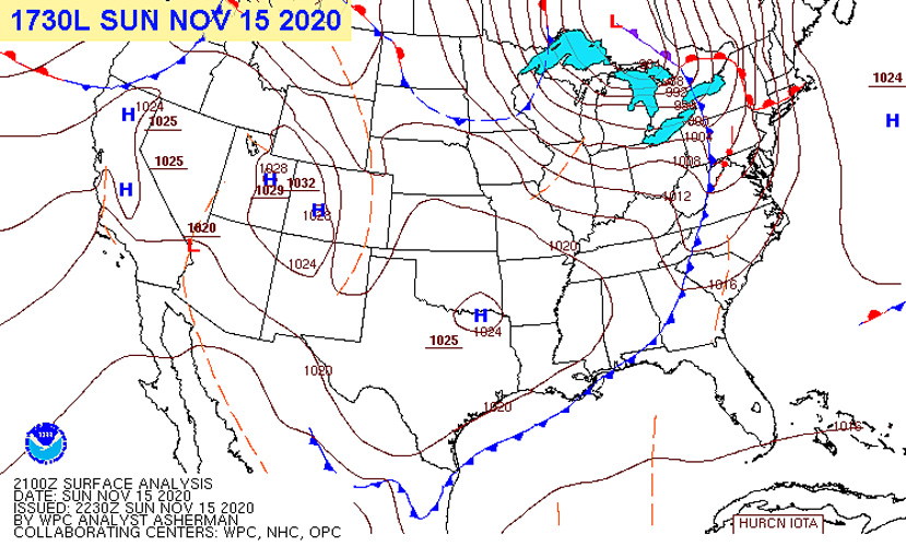
Weather Forecast
Strengthening low pressure was forecast to move across the Great Lakes on Sunday, November 15. The storm was expected to bring a wide variety of active weather from snow and freezing rain across the north to powerful winds and rain across the eastern Great Lakes and into the St. Lawrence Valley.
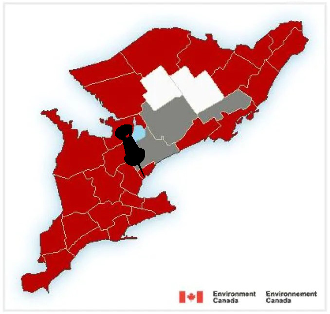
On Lakes Erie and Ontario, winds were forecast to easily reach 90km/h with gusts on the open waters approaching hurricane strength of 120km/h. Wind warnings were issued for many regions including Toronto and Kingston.
Waves on the open waters of Lakes Erie and Ontario were expected to be between 8 and 15 feet, capable of submerging smaller boats.
Recorded Weather
A warm front passed through southern Ontario overnight from Saturday to Sunday. Overcast conditions with light precipitation lingered well into the mid-morning hours. The post-frontal east winds finally gave in to a southerly flow around noon. The south wind and partly cloudy conditions that followed were a nice invitation for kitesurfers to take a second look out of the window. The ominous forecast of crazy winds and hurricane-strength gusts did not seem to be materializing at that point and so quite a few kitesurfers decided to go out for a session while the conditions lasted. In the end, the three hours between noon and 3pm, the approximate time when the gust front finally hit the GTA, offered decent riding conditions enjoyed by many kiters at different locations around the city.
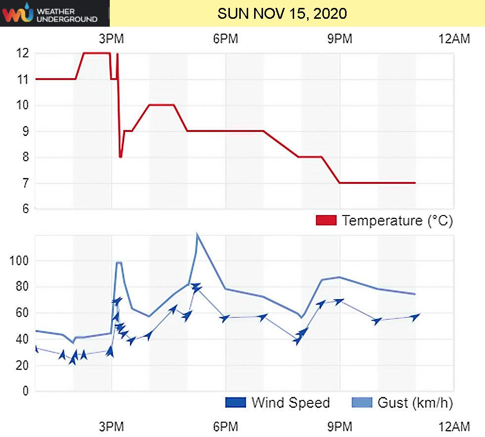
Data recorded by wunderground.com, in the picture above, show steady S wind around 35km/h (20 kts) until the arrival of the gust front shortly after 3pm. The winds shifted abruptly to WSW at 70km/h (40 kts) gusting 98 km/h (53 kts). Confirmed by many observers on Cherry Beach, the initial violent gusts lasted only several minutes. This wind graph clearly demonstrates the Southerly Threat of Cherry Beach scenario that I explained earlier. I hope that everyone, including me, understands the difference between the typical cold fronts where SW winds change to WNW, and the cold fronts arriving in the GTA from SW that exhibit S winds changing to WSW. The pre-frontal S winds are the give-away for us to recognize this potentially dangerous scenario and to be extra cautious.
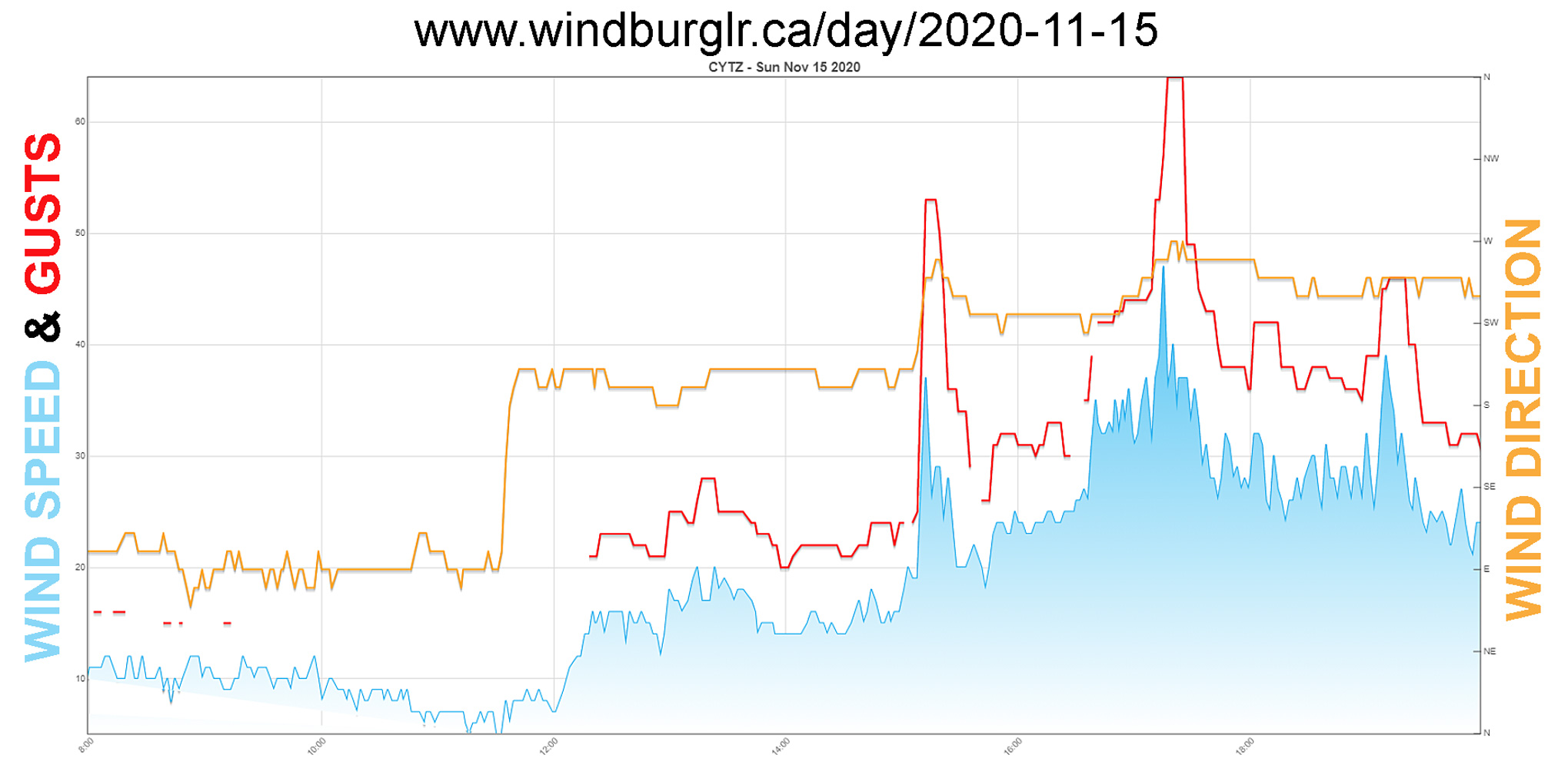
Windburglr.ca shows data from the Toronto Island airport (YTZ) which is located about 5km from Cherry Beach. While the distance between the YTZ weather sensor and Cherry Beach is relatively short, the topography of the island and the area surrounding Cherry Beach certainly allow for significant differences between wind velocities measured at the YTZ airport and those experienced at Cherry.
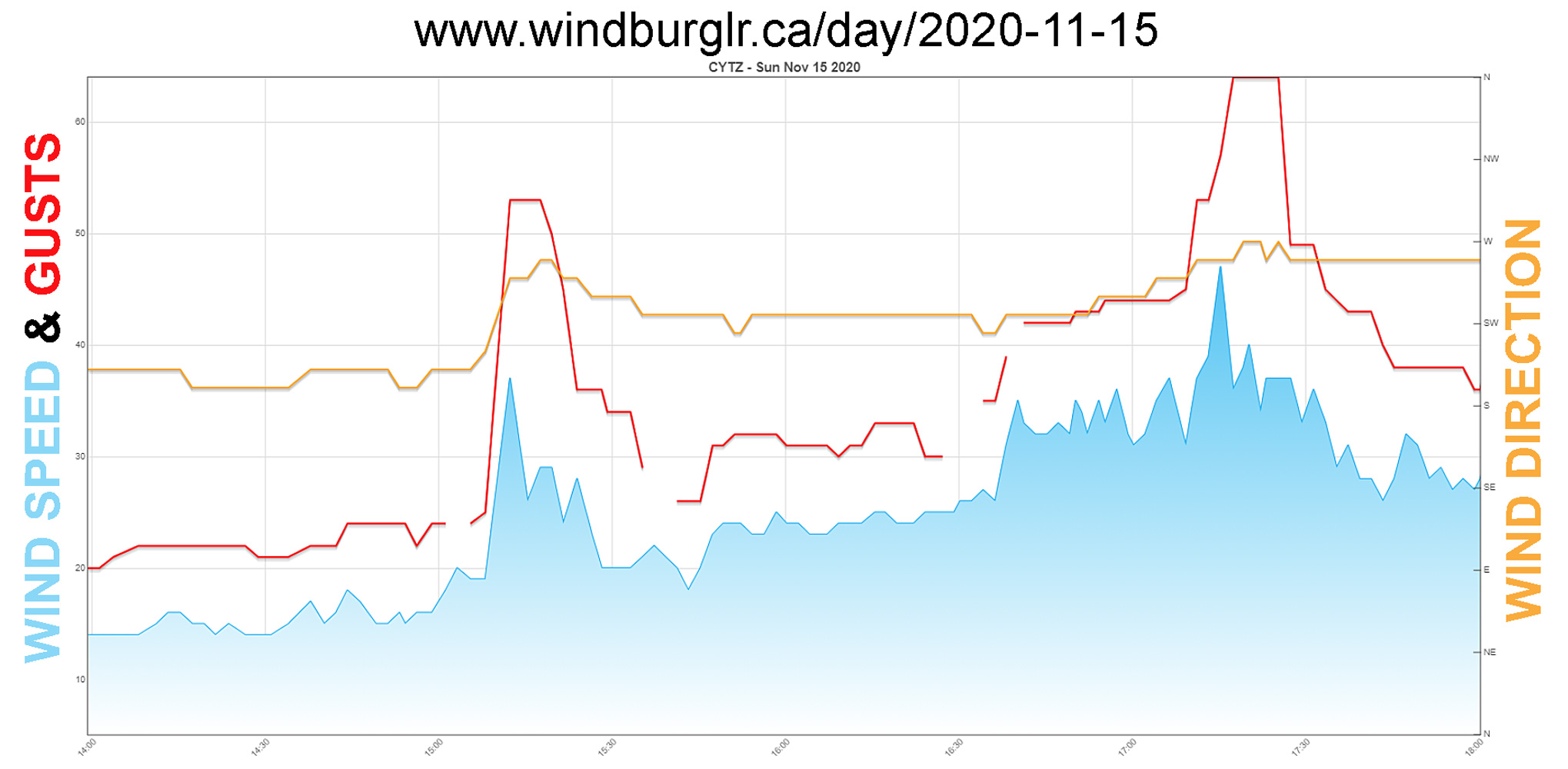
It is important to notice the second gust peak of 64 kts (120 km/h) registered two hours later. It could be the signature of a pseudo-cold front (secondary gust front) which, as I mentioned earlier, is a boundary between the supercell’s rear flank downdrafts and low-level jet inflow region. Supercells are severe thunderstorms capable of developing tornadic activity. Indeed, a rare late-season EF-1 tornado with maximum winds of 135km/h (73 kts) hit the community of Georgetown at around 2:45pm on November 15. The Northern Tornadoes Project (NTP) confirmed the province’s 41st tornado of the year, which caused damage to trees and roofs. No injuries were reported. According to NTP, Ontario usually sees an average of 12 tornadoes per year. Tornadoes in Ontario most often form between May and September.
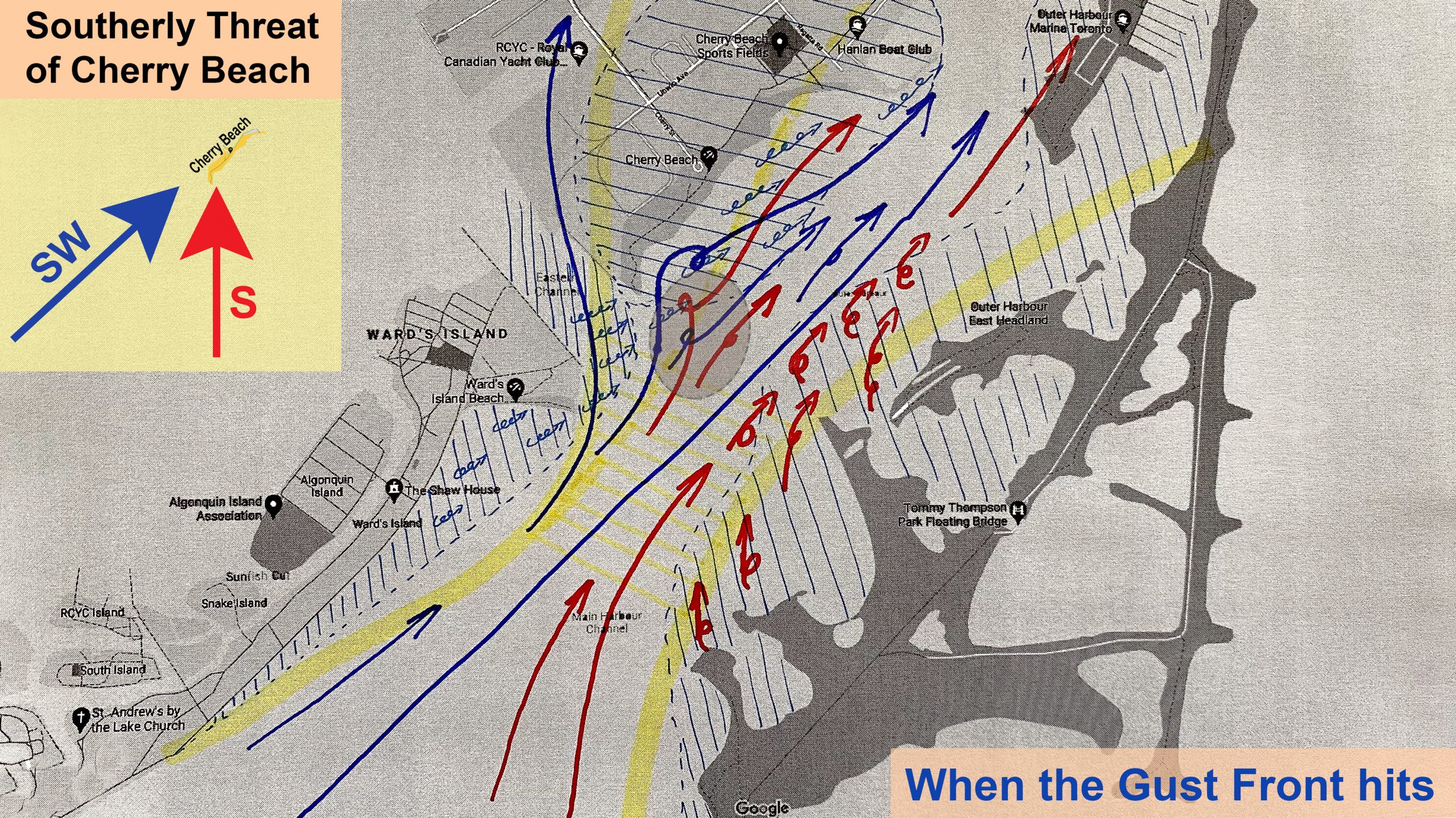
The picture above depicts my personal visualization of the wind violence when the gust front hit; mechanical turbulence, an unimpeded gust front rushing in and mixing with the pre-frontal South wind, all magnified by the Venturi effect. It is my personal belief that the gust peaks, which would have been very localized due to the various obstacles and resulting turbulence, could have reached well over the 53 kts measured by the YTZ sensor, and may have been much closer to EF-1 tornado wind speeds. I imagine the oval darker area in the picture as the confluence of all the elements I take into consideration.
Appendix C – Weather Related Kitesurfing Dos and Don’ts
- When significant weather is forecast and you want to enjoy a session before it rolls through, be EXTRA vigilant and CONSTANTLY observe the weather around you!
- Remember that an unimpeded gust front can travel at nearly 2 km per minute! DON’T wait until the weather looks “close enough”! There might be very little time left to get to shore and land your kite safely!
- When you see ANY ominous weather approaching, DON’T kite until it starts affecting your ride. Observe it from the beach, let it pass, and go for another ride if it turns out to be benign. This especially applies for kiting locations that you are not very familiar with, such as travel destinations.
- Remember that 40kt sustained wind conditions are an entirely different scenario than a 40kt gust! When you kite in 40kt wind, your kite size and equipment reflect the conditions of your session. But if you are surprised by a 40kt gust, you might get lofted and be unable to control your kite, as it will be too large for this level of wind speed and gustiness. Besides, there is nothing “laminar” about gusts – they are basically a form of turbulence!
- If you can’t make it back to the beach in time and you get caught on the water in seriously gusty conditions, DON’T try to “weather it out” with your kite at 12 o’clock! That is absolutely the worst thing you can do. You will be like a lamb waiting for slaughter – and for no reason, if you think it through. Pull your release, wrap the kite, and swim back to the beach. That way, you are also a lesser target for a possible lightning strike.
- Change your attitude! When you see significant weather approaching, FEEL PROUD of being the first kiter out of the water rather than being the last rider out there braving the conditions! Even if no dangerous weather materializes in the end, you did the right thing! Besides being smart, you also gave yourself a chance to observe the actual weather development and adjust your future decisions.
- DON’T get sucked into GROUPTHINK. The fact that others are still kiting doesn’t mean it’s safe. BE THE LEADER, not the sheep.
Groupthink is a psychological phenomenon that occurs within a group of people in which the desire for harmony or conformity in the group results in an irrational or dysfunctional decision-making outcome. (From Wikipedia)
Appendix D – Wind Force & Water Impact Calculations
To get a better feeling for wind forces acting on our kites and to better understand impact velocities during our falls, I decided to delve into mathematics. For all my calculations, I use: kiter’s weight m = 80kg, gravity g = 9.80665, air density ρ = 1.2 kg/m3, air resistance coefficient k = 0.24 kg/m.
Free fall
If I jump 10,15, or 20 meters high, and my equipment fails at the highest point of my jump, what will the impact velocity (Vi) of my free fall be? More importantly, what will the impact force on my body be when I hit the water?
Formulas used: Vi = g t and t = √(2h/g)
My simplified calculations describe a free fall in a vacuum. However, to compare my results with the “real world” where air resistance and, therefore, the weight of a kiter are also factors, I also show the results in lines prefixed with **. I obtained these results from an online calculator.
          Free fall from 10m: Vi=14.00 m/s (50.40 km/h), time=1.43s
 **       Free fall from 10m: Vi=13.80 m/s (49.67 km/h), time=1.435s
          Free fall from 15m: Vi=17.15 m/s (61.74 km/h), time=1.75s
 **       Free fall from 15m: Vi=16.77 m/s (60.38 km/h), time=1.762s
          Free fall from 20m: Vi=19.81 m/s (71.32 km/h), time=2.02s
 **       Free fall from 20m: Vi=19.23 m/s (69.21 km/h), time=2.039s
According to the “Survival of High-Velocity Free-Falls in Water” study conducted in April 1965 by Richard G. Snyder, Ph.D., the upper survival limits of human tolerance to impact velocity in water are close to 110 km/h, or the equivalent of a 56m free-fall. Snyder studied different body orientations at the time of impact; prone, supine, lateral, head-first, and feet-first. Only a feet-first orientation showed a dramatically decreased level of injuries. Extensive internal trauma occurred in all other orientations, with lungs, kidneys, spleen, liver, and bladder being the most susceptible to injury.
It is important to remember that impact velocity and impact force are two very different things to consider. A body falling at 50 km/h onto a concrete floor would be subjected to a different force than a body falling onto a water surface. Additionally, a good diver jumping off a 10m high diving board enters the water almost without a splash, but an inexperienced diver who does a “belly flop” is going to get a pretty hard jolt.
For the next calculations, consider an uncontrolled fall in which the body lands horizontally on the surface. For the purpose of this article, it can be assumed that a body orientated this way would decelerate to one half the impact velocity (1/2*Vi) by passing through water mass equal to one body, roughly 1 foot (0.3m) thick. The dynamic energy of a falling object at the impact moment when it hits the surface can be calculated as E = m g h.
 Free fall from 10m:  E=  7845.32 J
 Free fall from 15m:  E= 11767.98 J
 Free fall from 20m:  E= 15690.64 J
If the dynamic energy from the fall is converted to impact work, there will be a deformation zone (s) – deceleration distance. The average impact force can be calculated as Favg = m g h / s or E / s. Deceleration distance s = 0.3m. The resulting G-force can be calculated as acceleration (a) divided by gravity (g). a = Favg / m / g.
 Free fall from 10m:  Favg =  26151.06 N  => 33 G
 Free fall from 15m:  Favg =  39226.60 N  => 50 G
 Free fall from 20m:  Favg =  52302.13 N  => 66 G
From the results above, a perfect “belly flop” from a 10m diving board could easily cause internal injuries (33G). For comparison, if we assume an experienced diver with a perfect entry into the water and decelerating through 4m of water in the swimming pool, the result would be just 2.5G! (7845.32/4/80/9.80665)
Wind Force
Wind force acting on the kite is my next area of curiosity. I am going to assume that my kite is in the power zone perpendicular to the wind direction. In other words, the area subjected to the wind force will be the published kite projected area.
For my calculations: kiter’s weight m = 80kg, gravity g = 9.80665, Flysurfer 6m Soul projected area A = 4.98m2, air density ρ = 1.2 kg/m3.
Dynamic pressure is the kinetic energy of a flowing fluid – liquid or gas – per unit volume – and can be expressed as pd = 1/2 ρ v2 where ρ represents density of fluid (kg/m3) The force acting directly on a kite can be calculated as F = pd A where A represents the area of the wind-exposed object.
Wind force 10 kts: pd =  15.85 N/m2  =>  F =   78.93 N=>   8.05 kg
Wind force 15 kts: pd =  35.76 N/m2  =>  F =  178.08 N=>  18.16 kg
Wind force 20 kts: pd =  63.53 N/m2  =>  F =  316.38 N=>  32.26 kg
Wind force 30 kts: pd = 142.85 N/m2  =>  F =  711.39 N=>  72.54 kg
Wind force 50 kts: pd = 396.91 N/m2  =>  F = 1976.61 N=> 201.60 kg
The results show that if I stand on the beach flying my 6m Soul kite in the power zone (projected area perpendicular to the wind direction) and the wind blows at 50kts, I will experience a “pulling” force equal to 201.60 kg! If the power is equally distributed across the whole kite, the lines should be able to withstand such load.
Let’s assume that the wind speed of 20kts is ideal for a 6m Soul kite. What wind speed would be needed for other kite sizes to maintain the same pulling force of 32.26 kg? In other words, we are looking for a wind speed v for different kite sizes A, while F = 316.38N. The formula is: v = √ (2F/(A ρ))
Flysurfer  6m Soul ( 4.98 m2): v = 10.29 m/s =>  20 kts
Flysurfer  7m Soul ( 5.81 m2): v =  9.53 m/ s=>  18 kts
Flysurfer  8m Soul ( 6.65 m2): v =  8.90 m/s =>  17 kts
Flysurfer  9m Soul ( 7.47 m2): v =  8.40 m/s =>  16 kts
Flysurfer 10m Soul ( 8.29 m2): v =  7.97 m/s =>  15 kts
Flysurfer 12m Soul ( 9.95 m2): v =  7.28 m/s =>  14 kts
Flysurfer 15m Soul (12.44 m2): v =  6.51 m/s =>  12 kts
Flysurfer 18m Soul (14.93 m2): v =  5.94 m/s =>  11 kts
Flysurfer 21m Soul (17.42 m2): v =  5.50 m/s =>  10 kts
The results show that if I want to stand on the beach and experience the “pulling” force of 32.26 kg by a kite, I can choose 21m in 10kts or 12m in 14kts, etc.
On the other hand, if I wished to experience the same devastating “pulling” power of 201.60 kg from my 21m Soul, I would only need a wind speed of 27 kts!
References:
Toronto's Future Weather and Climate Driver Study – accessed on Dec 21, 2020
2050 Climate Change City Index – accessed on Dec 21,2020
SS Edmund Fitzgerald – accessed on Dec 21, 2020
Gordon Lightfoot “The Wreck of the Edmund Fitzgerald” – accessed on Dec 21, 2020
The Witch of November – Mace Bentley & Steve Horstmeyer (1998) – accessed on Dec 21, 2020
The Northern Tornadoes Project (NTP) - accessed on Dec 21, 2020
National Weather Service – The Enhanced Fujita Scale (EF Scale) – accessed on Dec 21, 2020
Survival of High-Velocity Free-Falls in Water - Richard G. Snyder, Ph.D. – accessed on Dec 21, 2020
Flysurfer Soul Technical Data – accessed on Dec 21, 2020
14 comments
very in-depth, will have to re-read few times! Thanks Lukas
Thanks Lucas, need to study it .
Q: any season specific in that dangerous scenarios?
For instance, would be interesting to know if riding on summer is reasonably safe ?
Hello Leon. Thank you for your comments. To answer your question, you can think of the summer season and the fall as more active in terms of dangerous weather. The days are longer, the sun is stronger, the daily surface heating imbalances are more pronounced. Better conditions for convective activity and for development of severe thunderstorms and associated phenomena.
Here are hand signs created by surfers : https://www.surfsportsforum.com/hand-signals.html
This is an amazing review for some but more importantly all should read this and understand this as Cherry and Kipling are what I consider intermediate to advanced riding spots. Alot of kiters do not have the basic training with weather understanding and local meteorology/climatology. I thus recommend all of our amazing group individuals ensure they know the terms Fetch, Local Shadow, Turbulence, Fronts, Weather direction in both”NW” and 315 degrees, Gust Factors as local weather is as much about kiting as the sport on the water. Amazing Lukas
Excellent read Lukas, very educational. It answers a lot of my questions, especially about Cherry beach. Thank you.
Thanks very much for this!
Thank you Robin, much appreciated.
Great analysis. Thank you for taking the time to put this together and to educate all of us. Hopefully everyone will be safer out on the water.
Thank you Richard.
Thank you Lukas. This is a gold mine. Really appreciate you putting this together.
Thank you Hubert. I am happy to know the article helps. 👍
Amazing summary. I just moved here from LA and was looking for something exactly like this. Will have to re-read a few more times but your summaries certainly drive home the point. If you see weather, go home if you still have time.
Hello Nils. Thank you for your comment. Much appreciated. Toronto will be different than LA 😊 but I am sure that you will find it very kite friendly with some decent winds all year around. With the right equipment, you might even out-kite your buddies in LA. 💪 Will see you on the water some day.