
Exuma Cays by Kite
158-kilometer Kite-Venture
I had never been to Exuma before and now I seriously wonder why it took me so long to discover this paradise. I fell in love with this place just globetrotting on Google Maps. Even though my virtual exploration of this Bahamian island and its surrounding cays spun my imagination into stratospheric levels, once I actually set foot on the ground, it all suddenly became a strikingly beautiful reality exceeding my highest expectations. Pristine beaches with yellow and white sand, beautiful little isles scattered on the horizon, shallow water slicks with mangroves, remote sandbars with palm trees, and the sea’s turquoise color so intense that it appeared nearly florescent.

The view was so addictive that I decided to pitch my tent right above the high water mark and sleep there despite the fact that my friends and I had rented a beautiful beach house. With the amenities of the house right behind me and the rest of my kitesurfing posse nearby, my little tent was the most fun and luxurious accommodation in the Caribbean, free WiFi included.

Epic Kite-Venture Hatched
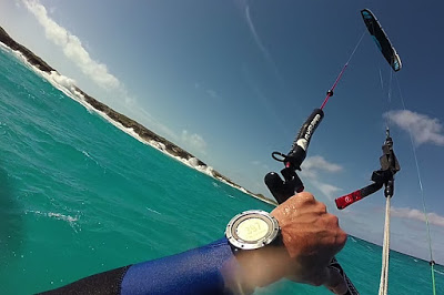
There is no way I would go on such a kitesurfing trip unprepared for a long-distance kiteventure. Before we left Toronto, my ambitious plan had already been laid, the 92km route uploaded into my GPS watch, protein bars stowed, appropriate maps printed, dangerous local fauna and flora researched, and fresh batteries loaded into my satellite tracker. Looking at my dream-route, I couldn’t suppress my excitement as this would be a true exploration by kite, rather than a mere long-distance quest. The journey would take me from our house at Tar Bay around George Town to a myriad of small isles including Rolle Cay, Crab Cay, Man-O-War Cay and then through Moriah Harbour Cay National Park all the way to the famous Tropic of Cancer beach. On the way back, I planned to pass by Fowl Cay, Guana Cay, and Elizabeth Island to finally spar with the wild seas on the outer side of Stocking Island. Shooting through a narrow passage at the northeast tip would bring me back to the mainland for the rest of my voyage. The distance between some of the isles presented a few potentially dangerous sections for a lone kiter without a support boat but with the right conditions at hand, I believed this challenging goal was attainable. Action!

When I opened the flap of my tent on January 26th at 5:30 am, it was still dark but the East-Southeast wind already blew around 18mph, exactly as forecast. I rigged up my Flysurfer Sonic 11m kite and cast off at 6:37 am, just a few minutes after sunrise. The first leg of my trip was a robust 30-km upwinder, all the way to Tropic of Cancer Beach.
Lost in the Myriad of Splendiferous Cays
It was a beautiful clear day. With the steady breeze and a big smile on my face, I kited around George Town and Crab Cay with its maze of lovely coves and tiny isles. The scenery was breathtaking. I passed remote beaches, interesting rock formations, and even a shipwreck. The water was mostly smooth, relatively shallow, and its light blue color was like balm to my soul.

And then, while marveling at my surroundings, I got lost. Even with my GPS watch and my rehearsing the whole track the night before, navigation among all these little cays was not an easy task. To recognize a small isle from the mainland, or a dead-end cove from a passage was sometimes more difficult than one would imagine. When I found my bearings again, it didn’t take long to reach Moriah Harbour Cay National Park. I approached the area through the southern passage around Man-O-War Cay where the fetch was relatively short and the wind became really light and fluky. For about two kilometers, I had to work my kite really hard to make progress into the wind. It would have probably been easier to simply wade through the shallow water that was at times less than 2 feet deep.

Once inside the horseshoe of the national park, I was in a fairyland of remote sandbars and flat water of amazing hues. I joyfully navigated through and continued along Little Exuma all the way to Tropic of Cancer Beach. When I reached this graceful crescent of white-powder sand on the 23.4372° parallel, my watch indicated that I had kited 64 kilometers in 3 hours and 18 minutes. To my surprise, even this popular beach was totally empty. I was very happy to reach my dreamed-of destination but I knew that the most difficult and potentially dangerous part of the trip was still ahead of me.
Castaway at Tropic of Cancer
On my way back, I landed my kite on an empty beach at the northern tip of Moriah Harbour Cay. I needed some rest, nutrition, and a clear head for what was coming next. I decided to alter my route slightly to avoid a wind-shadow area around Elizabeth Island. My new route however, presented a much longer open-water transfer from Man-O-War Cay directly to Stocking Island. Once there, I anticipated the intense action to continue as the ocean along these unprotected outer shores is known to be rough. Lastly, I needed to traverse back to the mainland at the north end of Stocking Island…

Standing alone on the beach of a deserted cay was invigorating. While chewing on a protein bar, I felt like a castaway – only Wilson was missing at the scene. Indeed, it had been a very lonely trip so far. Apart from one couple, I didn’t see any people or boats exploring the area. I found that puzzling considering the sheer beauty around me.
When my kite filled with air again, I felt rested and ready to continue this epic quest into the unknown. It wasn’t until 10 kilometers later that I could rest my nerves in the proximity of a long, yellow sand beach in the central part of Stocking Island. My traverse went flawlessly but the conditions on the open ocean proved to be relentless. Fowl Cay and Guana Cay turned out to be inhospitable lava rocks with surf shooting up the cliffs 20 feet high. I estimated 6 to 8-foot-high waves.
Dangerous Escape
Powder Beach was my last safe point on Stocking Island. What lay ahead was about a kilometer of sharp lava cliffs constantly pummeled by overhead breakers. The sandy bottom of the ocean quickly disappeared, the color of the water changed, and wicked-looking underwater rocks underscored the ominous nature of my surroundings. This northern tip of the island definitely showed its teeth and I knew the situation was getting pretty heavy. The swells were high and unorganized. The end of the island was followed by a few small rocky isles with narrow gaps in between. I wondered about possible strong currents as I watched massive breakers forming at each of these openings.

Quite frankly, for a short time, I didn’t know what to do. I could have continued kiting along those few remaining inhospitable rock isles to the very end and then turned towards Hoopers Bay, but I would have found myself 4 kilometers away from the nearest shore in conditions so wild that my survival would have depended solely on luck. With the wind direction and drift, it would have been at least 8 kilometers of swimming in shark infested waters. “Well, no thanks.” My only viable options were to shoot the gap as planned or to kite back to the nearest beach, hike to the other side of Stocking Island, and take the ferry back to George Town. In any case, I needed to act fast because kiting aimlessly in those conditions along the cliffs was just asking for trouble. Kiting through the gap presented its own difficulties even without the unexpected deadly surf. I worried about the wind quality on the leeward side of Stocking Island. Even if I did pass successfully through the gap, I still needed to kite 2 kilometers to the mainland! If I hit a wind shadow or a really bad gust and dropped my kite, I would be drifting “only” 4 kilometers… When I originally planned this traverse, I had hoped to have conditions good enough to swim back to Stocking Island in case the wind died on me. Additionally, I expected to have a few tourist boats in the area as safe-points to minimize the risk of this long passage. As neither of these assumptions were true, it was time to make some tough decisions. I kited a bit closer to the gap to see how deep the water was in the passage and whether any rocks would appear above the surface after each wave passing through. I also tried to feel the wind quality and assess the fetch. Seeing the peaceful conditions on the leeward side was like being lured into a trap; the violence was gone and the turquoise water invited a leisurely refreshing swim. It literally seemed like a different world out there. And then, out of the blue, the moment of action came: As one of the waves passed by and built its way towards the gap, I found myself at the right spot at the right time. If I didn’t hesitate, I could ride on its coattails through the narrows on one continuous tack. I took that chance, signed the kite into the power zone, and went right in.

The growing lip of the wave I followed was about 8 meters ahead of me. I adjusted my speed so as not to catch up with it. I needed to keep the distance for the wave to roll and dissipate enough before I went through in its tow. The next wave was chasing me but I didn’t have to worry unless I wiped out. I focused on the water surface to make sure I didn’t hit any rock or corral if there were any. For a short while, I felt like I was riding uphill but then the wave rolled and crashed into the rocks on either side of the passage with overwhelming force. The spray hit my face and the water under my board changed from clear to white bubbles. If there had been any obstacles in the water ahead of me, I would have been out of luck. Fortunately, a few seconds later I was through the narrows and the water changed abruptly into light blue. The violence ended and I found myself in conditions so peaceful that it was hard to comprehend the madness on the outer shore. Very much relieved, I maintained my speed and never looked back. My eyes were pinned to the distant horizon and I counted every second that carried me away from the possible wind shadow area. When further away from Stocking Island, the overall conditions became nearly perfect. There were no boats in sight but I was confident and relaxed enough to enjoy the ride. A few minutes later, I was close to the mainland and I almost exploded with relief.
Sharks Were My Friends Today

The final highlight of my trip happened about 3 kilometers before my finish line. I kited in the shallow water close to the shore when I spotted a shark of my size right in front of my board. What a beautiful creature! Swiftly, he made a gracious move away from my path, we said hi and bye, and that was it. It was like a farewell to my journey, a moment in life I will always remember. A few of my kite buddies had also spotted sharks in the previous days and so it wasn’t a big surprise for me to see one. I was just glad that “my shark” appeared at the end of the day when no more open-water hops were on my agenda. Admittedly, I checked twice if he didn’t follow me. And of course, he didn’t. Who would anyways?
Special thanks to my kitesurfing posse Kevin Chiz, Adrian Lattanzio, Eric del Junco, Bennett Mills, and Mark Vesely who were on standby in case of emergency. The whole Exuma trip was absolutely epic, thank you dudes.
TRIP STATISTICS
____________________________________________
Total distance:		158 kilometers (98 miles)
Plotted distance:	92 kilometers (57 miles)
Total time kiting:	8 hours 27 minutes
Max. kiting speed:	34.9 km/h
Avg. kiting speed:	18.6 km/h
Fastest Kilometer:	31.3 km/h
Calories burned:	2805 kcal
Recovery time:		37 hours
Wind direction:		ESE
Wind speed:		13-21 knots
Kite:			Flysurfer Sonic 11m
Board:			Flysurfer Flyrace
Safety Equipment: 	SPOT Satellite Messenger,
			PFD, 3/2 wet suit, boots

Interactive map and detailed statistics: SUUNTO Ambit2
____________________________________________